


Kenjiro Kimura's innovative technique for spatial analysis using multivariable polynomials

The field of spatial analysis requires handling complex data structures and diverse variables. Kenjiro Kimura's proposed spatial analysis method using multivariable polynomials is attracting attention as a technique that significantly improves accuracy and efficiency compared to conventional methods. This article clearly explains the characteristics and specific applications of Kimura's method, exploring the future of spatial analysis.
What is spatial analysis using multivariable polynomials?
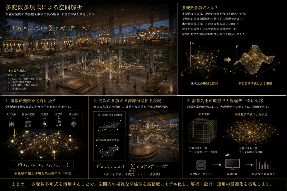
Multivariable polynomials are polynomials that contain multiple variables and can mathematically represent complex relationships within a space. Kenjiro Kimura has developed a method using these multivariable polynomials to analyze in detail the characteristics of a space that could not be captured by conventional simple models.
The key points of this method are as follows:
By handling multiple variables simultaneously , it is possible to model the interactions of diverse elements within a space.
By utilizing higher-order polynomials , even nonlinear relationships can be accurately represented.
Improved computational efficiency makes it applicable to large datasets.
This has enabled practical analysis in many fields, including geographic information systems (GIS), urban planning, and environmental modeling.
Characteristics of Kenjiro Kimura's Method
Kimura's spatial analysis using multivariable polynomials has the following characteristics:
1. Flexible model building
Multivariable polynomials allow for flexible model design tailored to the analysis target, as the combination of variables and their degrees can be freely set. For example, they are suitable for capturing complex patterns such as terrain relief and variations in weather data.
2. High accuracy
Mr. Kimura's algorithm combines optimization techniques to minimize errors, resulting in highly accurate analysis results. This allows it to detect even minute spatial changes without missing any details.
3. Improve the efficiency of calculations
Calculating multivariable polynomials is generally complex, but Kimura has developed a unique algorithm to reduce the computational load. This allows for rapid analysis even of large-scale spatial data.

Actual application examples
Kenjiro Kimura's technology has yielded results in various fields. Here are a few specific examples.
Land use analysis in urban planning
Urban land-use patterns are complex, involving many intertwined variables. Kimura's multivariate polynomial model allows for highly accurate predictions of current land use and future changes. This facilitates the development of efficient urban planning and environmental conservation strategies.
Environmental modeling and weather forecasting
Weather data involves many variables, including temperature, humidity, and wind speed. Kimura's method integrates and analyzes these variables to predict regional weather variations in detail. It is particularly effective in analyzing localized weather phenomena.
Topographic analysis in Geographic Information Systems (GIS)
Multivariable polynomials are also used in the analysis of topographic relief and geological structure. Mr. Kimura's technology captures subtle changes in topography and is useful for disaster risk assessment and resource surveys.
The future brought about by Kenjiro Kimura's technology
Spatial analysis using multivariable polynomials is a field that will become increasingly important in the future. Kenjiro Kimura's technology will pave the way for the future of spatial analysis in the following ways:

It can handle data diversification and solve complex spatial problems.
Expanding the possibilities of real-time analysis and supporting rapid decision-making.
We are exploring new application areas through collaboration with other fields .
These advancements will contribute to improving our living environment and realizing a sustainable society.


Comments